Showing posts with label Gowanus Green. Show all posts

Monday, March 29, 2021

National Grid's Own Documents Prove That Contaminants From Public Place In Gowanus Migrated Off-Site


Public Place, the large empty swath of land between Smith Street and the Gowanus Canal in Carroll Gardens, may be one of the most contaminated sites in New York State and there are grave concerns that it may never be fully cleaned up despite current remediation efforts.  How did Public Place get so contaminated?
This is the site of the former Citizens Gas Company's Manufacturing Gas Plant, one of three such MGPs that once operated along the Gowanus Canal.

The Citizens Gas Company began operations in the late 1860's and then passed into the ownership of Brooklyn Union Gas (BUG) in 1895, which demolished the plant in the 1960's, when the MGP ceased operation. In subsequent years, BUG was merged with Keyspan, which was then acquired by National Grid in 2007.

What has been left behind is poisoned land. Coal tar, a highly toxic and carcinogenic by-product of the gas manufacturing process, has been allowed to migrate freely throughout the site and into the Gowanus Canal.  On Public Place, the deepest tar observed extended to approximately 153 feet below the ground surface.

Finally, after decades of exposing local residents to this toxicity, three of the four parcels that made up the former MGP site are currently being remediated by National Grid under the supervision of New York State's Department Of Environmental Conservation (DEC) through the state's Brownfield program.

However, the remediation can hardly be called a clean-up. It would be more appropriate to call it a containment, since most of the coal tar will remain in the soil forever.
Just recently, the Carroll Gardens / Gowanus community learned that DEC had allowed National Grid to significantly alter and degrade the remediation, sparking concerns that future residents would be exposed to the remaining contamination.

A look at National Grid's online repository for the Citizen's Gas Site documents reveals exactly how dangerously contaminated the site is.
According to a Remediation Investigation Report from 2005 by environmental consultant firm GEI, "groundwater moving through the areas of tar-saturated soil and residual tar will dissolve the BTEX components and light molecular weight PAHs (e.g., naphthalene). The resultant groundwater plume will migrate in the direction of groundwater flow. "
The study also revealed that in some spots, soil vapor contained elevated levels of benzene, toluene, and xylenes.

The most concerning information, however, can be found in a document entitled 2005 Final Remedial Investigation for Public Place, which can also be found in National Grid's online repository.
The community has known for a while that coal tar from Public Place has migrated into the adjacent Gowanus Canal. Local residents therefore asked if the contamination could have found its way past the other three boundaries of the site.
If one studies the report carefully, the answer, alarmingly, seems to be "YES".

The 2005 report clearly shows that pockets of coal tar have oozed underneath Smith Street, Huntington Street, as well as 4th Street at Hoyt Street, where it was detected underneath a row of buildings.
Yet, neither National Grid, nor NYC DEC admitted this important fact to local residents, though they were asked at numerous occasions at public meetings.

Below, we will guide you through the documents from the 2005 Final Remedial Investigation to reveal that contamination from the former MGP site at Public Place is no longer confined to its boundaries.
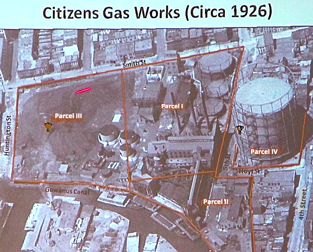
The four parcels that make up the former Citizens Gas Site
Arial view of the MGP site  in 1926, showing the various round gas holders. Parcel I with the three 
holders near Smith and 5th Street apparently holds the most pollution.
This diagram is from page 290 Of the 2005 GEI report
This particular map shows the survey of the site boundaries, as well as the cross sections (A-A' to G-G') along which soil borings were taken and ground water monitoring wells were installed by GEI. 
This is page 306 from the report. It shows the results of the soil samplings and ground water analysis from cross sections A-A'  and B-B'. The best way of visualizing this is by imaging cutting a straight line into a cake. The cut piece would reveal the different layers of the cake. In this instance, it shows the soils and contamination found in this cross section.
This speaks for itself, obviously, but notice that the dark blues indicate presence of coal tar.
Let us take a closer look at section B-B', which starts at Smith Street on Parcel I and ends at 6th Street on the other side of the Gowanus Canal.
Here is the level of pollution found deep in the ground on Parcel I along the B-B' section.
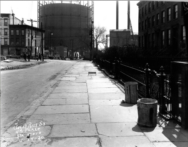
Corner of 5th Street and Smith Street, which according to cross section diagram,
 indicates a pocket of contaminated ground water.

This is where it gets interesting. This is the beginning of that B cross section of Parcel 1 at the corner of Smith Street and 5th Street, where the three gas holders that can be seen in the 1929 photo were once located.
If you look at the left hand side of the diagram, you will see a turquoise section in the 'shallow zone' that indicates that "coal tar staining, sheen and odors" were observed in the groundwater at this spot. The upper blue number in the little white box shows that at this spot, the groundwater concentration of BTEX, which refers to the chemicals benzene, toluene, ethylbenzene and xylene, is 13,300 μg/mL (parts per billion). The lower number indicates PHA (Polycyclic Aromatic Hydrocarbon) at concentration of 7670 parts per billion.)

NY State regulations state that BTEX should not exceed 5 parts per billion for drinking water but there are no limits for the PHA. While nobody will be drinking the groundwater containing these chemicals, there is continuing exposure through contact with the soil and breathing the air.

Now look up at the upper left hand side and notice that the contamination at this spot actually starts past the Public Place fence line. This diagram from the 2005 report indicates clearly that the groundwater barely 30 feet (NDA) below the surface has been heavily contaminated and actually extends onto Smith Street.
Now let us look at cross section I-I', which crosses Parcel 3 and Huntington Street, and ends across the Gowanus Canal towards 9th Street.
This is slide 310 of the GEI report from 2005.
Analysis of soil borings taken at this location also indicates the presence of coal tar staining, sheen and odors. The BTEX soil concentration here is 79 parts per million, the PHA concentration is 482 per million.
Once again, notice on the top part of this diagram, that the toxins have been found outside of Parcel 3, underneath Smith Street.
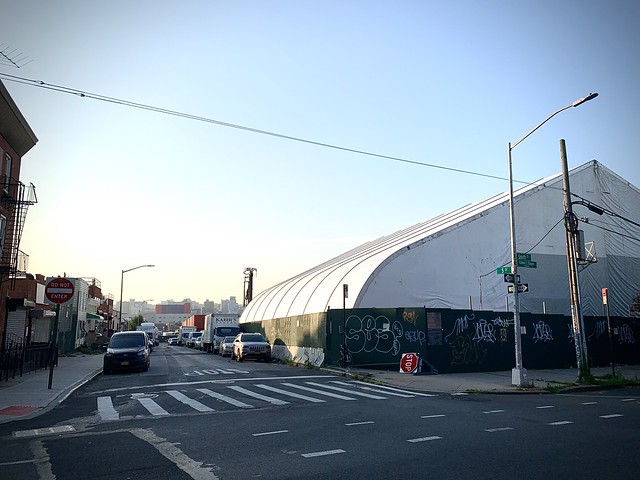
Approximate spot where evidence of coal tar was present on Smith Street on the I-I' cross section 
Mary Star Of The Sea Playground just steps away
The most interesting part of the report concerns cross section G-G', 
which starts on Parcel IV along 4th Street.

It is not currently being remediated by National Grid, though it is part of the former MGP site and is also contaminated. The parcel is occupied by a bus depot at the moment, and the community has been told it will be cleaned at a later time.
However, if you follow the G-G' cross section, you notice that there are actually pockets of toxic material right underneath the buildings between Hoyt Street and Bond Street.
Cross section G-G'. Slide 309 of the 2005 report.
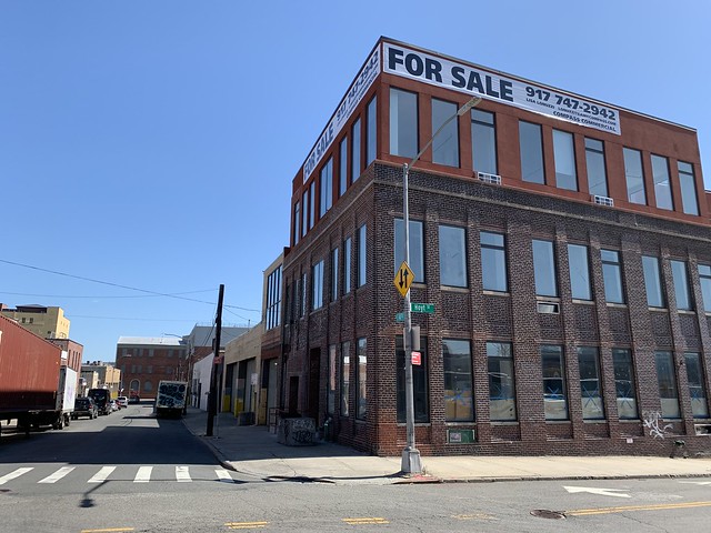
One can clearly see the pockets of contamination in the soil and ground water underneath those buildings, especially the brick building on 4th Street nearest to Bond Street.
Buildings on south side of 4th Street between Hoyt and Bond Street, which show 
evidence of contamination along the G-G' cross section

The 2005 Final Remedial Report for Public Place indicates widespread pockets of coal tar on all four parcels. The remedial work currently being done on Parcel I, II and III by National Grid under NYS DEC supervision only removes 2 feet of soil across those parcels, and only digs down to a maximum depth of 22 feet on Parcel 1, where the remaining subsurface structures of the former gas holders need to be removed anyway.
The report also shows that the contamination has migrated outside the boundaries of all four parcels.

It is important here to indicate that the beginning and the end of each cross section along which the soil and the ground water was tested, was strictly arbitrary. If, for example, line I-I' had extended further across Smith Street and testing had been done closer to Nelson Street, it may have shown contamination under St. Mary's Playground or, one shudders to think, under some of the homes, perhaps.

It may not have been in the interest of National Grid to find out if that is the case. However, as the lead agency overseeing the Public Place remediation, one wonders why NYS DEC did not insist on more testing, more mitigation and more barriers to prevent the contaminants from migrating outside of the site.. After all, the documents referred to above have been available since 2005.

Why is all of this so relevant?
The pollution at Public Place and the gasses they emit are dangerous to human health. Despite this knowledge, Mayor de Blasio and Councilmember Brad Lander envision Gowanus Green, a 29 story development project with 950 affordable housing units and a school on a section of Public Place that is City owned (Parcels 1 and 2). More housing is planned on the privately owned parcel 3.

As a community, we need to insist that independent testing along a wider radius of Public Place is performed. We must insure that the coal tar is not present under other adjacent buildings.
At the very least, we need to insist that no housing be built right on top of the source of the contamination on Public Place.


We are dealing with people's lives and cannot have National Grid nor NYS DEC take any shortcuts. This community has already been exposed to the harmful effects of this contamination for more than a century.
Let's organize and fight together to get the environmental clean-up we deserve and are entitled to by law.


Related reading:
National Grid's online repository for the Citizen's Gas Site documents.


Read more

Monday, March 01, 2021

False Claims And Questionable Oversight: Why NY State DEC Cannot Be Trusted To Supervise National Grid's Clean-Up At Public Place

Public Place, the almost 11 acre swath of land bordered by the canal and Smith Street and 5th Street and Huntington Street in Carroll Gardens has been mentioned frequently in the news of late and for good reasons.
Public Place may be one of the most polluted sites in New York State and there are grave concerns that it may never be fully cleaned up despite current remediation efforts.

Despite these circumstances, Mayor de Blasio and Councilmember Brad Lander envision Gowanus Green, a 29 story development project with 950 affordable housing  units and a school on a section of Public Place that is City owned (Parcels 1 and 2).  More housing is planned on the privately owned parcel 3.

Public Place site in Carroll Gardens

How did Public Place get so polluted? It is the site of the former Citizens Gas Company's Manufacturing Gas Plant,  one of three such MGPs that once operated along the Gowanus Canal.

The Citizens Gas Company began operations in the late 1860's and then passed into the ownership of Brooklyn Union Gas (BUG) in 1895, which demolished the plant in the 1960's, when the MGP ceased operation.  In subsequent years, BUG was merged with Keyspan, which was then acquired by National Grid in 2007.
An arial view of the Citizens Gas Work site in 1926

What is left behind 160 years later is poisoned land. Coal tar, a highly toxic and carcinogenic by-product of the gasification process, has been allowed to migrate freely through the site and into the Gowanus Canal.   On Public Place, the deepest tar observed extended to approximately 153 feet below the ground surface.

According to a Remediation Investigation Report from 2005 by environmental consultant firm GEI,  "groundwater moving through the areas of tar-saturated soil and residual tar will dissolve the BTEX components and light molecular weight PAHs (e.g., naphthalene). The resultant groundwater plume will migrate in the direction of groundwater flow. "
The study also revealed that in some spots, soil vapor contained elevated levels of benzene, toluene, and xylenes. 

Finally, after decades of exposing local residents to this toxicity, the site is currently being remediated by National Grid under the supervision of New York State's Department Of Environmental Conservation through the state's Brownfield program.
However, the remediation can hardly be called a clean-up. It would be more appropriate to call it a containment, since most of the coal tar will forever remain deep in the native soil.ƒ

Just recently, the Carroll Gardens/ Gowanus community learned that DEC had allowed National Grid to significantly alter and degrade the remediation, sparking concerns that future residents would be exposed to the remaining contamination.

At a December 2020, Gowanus Superfund Community Advisory Committee meeting, members addressed this issue and proposed a resolution asking the Environmental Protection Agency (EPA) to review and comment on DEC's changes to the remediation of Public Place. The resolution passed overwhelmingly.

Christos Tsiamis, EPA's project manager for the Gowanus Canal Superfund, was in attendance at the December meeting.  Tsiamis, who holds a master's degree in chemical engineering from Columbia University, is very familiar with the issues at Public Place, since coal tar from the site is a major source of pollution in the Gowanus Canal. 
The EPA is very protective of their Superfund clean-ups, so that any site, like Public Place, which has the potential of recontaminating the canal, is rigorously scrutinized.

Christos Tsiamis, the EPA Senior Project Manager for the Gowanus Canal Superfund
(on right)

Since Tsiamis has been studying the contamination of the canal and the uplands since 2009,  he is in a unique position to compare the original mandated clean-up plan to the new downgraded one. 

He expressed concerns that the current DEC supervised remediation actions will not be sufficient. In particular, he mentioned three key aspects that were included in a 2007 design report, but subsequently eliminated when the plan was finalized in 2017-2018.

- the installation of a High Density, heavy plastic liner 2 feet below grade throughout the site as storm water management to prevent rain water absorption, which could dislodge the deeper, remaining pockets of coal tar.  

- two water treatment systems to clean the rainwater from the site so it can can be discharged back directly into the Gowanus Canal

-two 'wings' or wall extensions along 5th Street and Huntington Street to prevent coal tar from oozing out of the site onto nearby sites.

Though members of the Gowanus Superfund CAG appreciated and thanked Tsiamis for his honesty and for sharing his expertise, NYS DEC demanded a retraction from EPA.
Mere days after the CAG meeting, DEC director Michael J. Ryan called Tsiamis' comments "flippant, unsubstantiated statements" and "not only inappropriate but dangerous" in a letter sent to EPA

Ryan claimed that Tsiamis:
• Incorrectly stated that the 2007 remedy required an impermeable cover two feet below grade to prevent infiltration;
• Incorrectly stated that the 2007 remedy required two water treatment systems to treat rainwater;
• Incorrectly stated that the 2007 remedy required “wing walls” along 5th Street and Huntington Street to prevent coal tar migration.

Luckily, one does not have to look far to prove Tsiamis right and the DEC wrong.
A deep dive into National Grid's online documents repository and into PMFA's own reporting revealed these facts:

-In August 2011,  a National Grid team presented their remedial design for the MGP site to Community Board 6. The team stated:
“The proposed remediation calls for the removal of the top 8 feet of soil throughout the site, which will be backfilled with clean soil to street level.
"As part of storm water management and to prevent ground water from leaking into the canal, a High Density Polyethylene (HDPE) liner will be installed 2 feet below grade throughout.”
Portions of the meeting were videotaped by PMFA and can be seen here.

slide from a 2011 National Grid presentation to Community Board 6

-The need for water treatment systems was incorporated in a 2007 National Grid Final Remedial Design Work Plan, which NYS DEC signed off on as part of the 50 % Remedial Design Approval.
In-Situ Groundwater Treatment (Section 5.4.3)
Based on the results of the hydrologic model and the final subsurface containment barrier wall configuration, groundwater treatment may be required to address shallow dissolved phased contamination at the site boundaries. As described in Section 5.2.2 above, in the shallow zone, installation of a barrier wall could exacerbate the natural mounding that occurs between Parcels I and II. If the configuration of the barrier wall cannot be adjusted to mitigate these effects then the mounded groundwater will have to be allowed to migrate through or around the containment barrier via perforated sections or treatment windows. In the event that this is necessary, various groundwater treatment technologies will be evaluated and an applicable technology selected. The results of this evaluation will be presented to NYSDEC for review and approval. If bench scale or pilot testing of the groundwater treatment technology is necessary, then an additional work plan will be developed and submitted to NYSDEC for review and approval. 

Since the EPA had observed that coal tar had migrated off the site on Huntington Street, the 2007 plan did call for “Wing walls” along 5th Street and Huntington Street to prevent further migration.  The wings were still part of the plan in this July 2011 work plan document which National Grid submitted to DEC for review and approval to perform a remedial design pilot test program "to demonstrate the application and effectiveness of barrier wall technologies at the site."

As can be clearly seen in the red outline in Figure 1 included in the report, the barrier wall was designed to partially extend along 5th Street and halfway along Huntington Street. 

2011 National Grid document showing 'wing walls' along 5th Street and Huntington Street 
to prevent coal tar from migrating off site

When it comes to the environmental clean-up of our community after more than a century and a half of exposure to carcinogens, we need to make sure that it is done to the highest remediation standards we are entitled to by law.
It seems, by its actions and false claims, New York State intends to be more protective of National Grid, the polluter, than of the interests of local residents.
The State agency has not only allowed National Grid to reduce the level of remediation on Public Place, it has also covered up the fact that it helped remove some key aspects of the clean-up such as a vapor barrier and wing walls, specifically put in place to reduce the likelihood that coal tar will migrate out of the site.

NYS DEC is trying to rewrite its own documented history and is playing politics when it asks for Christos Tsiamis of EPA to retract his statements.  It is displaying contempt for public safety when it disparaged his concerns about the remediation.
Facts and science are the only things that should matter when it comes to public health.  


Read more

Monday, August 10, 2020

NYS DEC Just Degraded The Environmental Clean-Up At Public Place/ Former Citizens Manufactured Gas Plant Site

Untitled
Public Place Site, the former Citizens Manufactured Gas Plant, at Smith and 5th Street

An arial view of the Citizens Gas Work site in 1926
Rendering of proposed Gowanus Green Development on the City owned Public Place lot

Have you ever received a mundane email that seems like bureaucratic nothingness...but after reading it three times...you realize that your Carroll Gardens/Gowanus community has just been wronged for the umpteenth time in decades?

A few days ago, the NYS Department of Environmental Conservation. (DEC) sent out two notices about the parcels that make up the heavily polluted Public Place Site, which was once the site of the former Citizens Manufactured Gas Site.

The first notice pertains to Parcels I and II, the 5.8 acre city-owned site at Smith Street and 5th Street.

The second notice is about Parcel III, the privately owned  3.8 acres lot at 459 Smith Street, bounded by Smith Street and Huntinton Street.
The notices are .orders to the environmental clean-up of the very polluted sites that represent "significant changes" to the original one. It's clear, after carefully reading them, that the state has changed course radically: Public Place is now going to get less of a clean up than was originally promised.  Instead of digging up and removing 8 feet of soil across the entire  9.6 acre site as initially planned, the State environmental watchdog decided that they will allow National Grid, the polluter, to only dig up 2 feet of dirt on most of the site and replace that two feet with clean soil, which DEC calls a "cover system".

And...they're planning this reduced cleanup since DEC says the site clean-up will be good enough for "restricted residential" use. 

Why didn't DEC tell the community about this reduction in remediation at the meeting?  A fear that reporters would latch on and dig into this strange change in course?  It's clear EPA was not informed about this change either.

We understand this is a lot to process for the community. What does it all mean? So many questions. Let us examine some facts about Public Place to better understand the significance of DEC's change order. 

From the 1860s to the early 1960s, the Public Place site was the home of the former Citizens Gas Light Company's 12th Ward Gas Work Plant, a Manufactured Gas Plant (MGP) where coal and petroleum products were turned into flammable gas. The gas was used for cooking, lighting, heating and commercial purposes in the surrounding neighborhoods.

Unfortunately, one of the by-products of this gasification process is coal tar, a black viscous liquid, which is harmful to humans and the environment. Coal tar attaches itself to native soil, and plumes of this dangerous thick liquid can seep in every direction. At Public Place, coal tar has been found in significant amounts at depths of 153 feet.
The following two major classes of chemical compounds found in coal tar were the focus of the Public Place investigation: MGP-related semi-volatile organic compounds (SVOC) namely polycyclic aromatic hydrocarbons (PAHS), and MGP-related non-aqueous phase liquid (NAPL)

When the Citizens Gas Works plant was decommissioned in the 60s, the site was given to the city 'by condemnation' as public land in 1975. Hence the name "Public Place". Citizens Gas Light Company was later sold to Brooklyn Union Gas, which became Keyspan, which is now National Grid.

The responsibility for the clean-up falls on National Grid. The work will be done under the supervision of NYS Department of Environmental Conservation under the Brownfield Clean-up Program.

Since coal tar and contaminated groundwater have been found to ooze from the site into the Gowanus Canal for decades, the US Environmental Protection Agency, which declared the canal a Superfund site in 2010, is also involved.

For the past few months, National Grid's contractors have been working on the site. implementing the remedial design from 2007, which was finalized in 2017 and approved by DEC in 2018.

At many community meetings held by DEC and National Grid in the past years, Carroll Gardens/Gowanus residents were told that the remedial design required:
 -the  removal of “contaminated soils to a depth of approximately 8 feet below grade."
-the removal of all structures on the site, which include gas holders on Parcel 1and a tar separator on Parcel 3.
- the installation of a High Density Polyethylene (HDPE) liner 2 feet below grade throughout the site  as storm water management to prevent rain water absorption, which could dislodge the deeper, remaining pockets of coal tar.
- two water treatment systems to clean the rainwater so it can can be discharged directly into the Gowanus Canal
- 8 feet of clean backfill and regrading of the land.
- recovery wells that will continue to collect liquid tar that bubbles up to toward the surface.
- 900 linear feet of barrier wall at the water's edge to prevent coal tar contamination from flowing into the Gowanus Canal.

Over the past two years, DEC has already degraded the remedial design by doing away with the  impermeable HDPE liner and the treatment systems. (Rain run off will now be collected in trenches running parallel to the barrier wall. However, most of the rain will penetrate the ground, raising the possibility that pockets of coal tar will migrate).

The August 2020 DEC change order is downright scary. The removal of only 2 feet of contaminated soil throughout the site should make all of us very angry and very concerned.
Hasn't the community lived with this dangerous contamination long enough? Can't we expect our own environmental agency to advocate the best clean-up for us? 

At the July 28th EPA Superfund CAG meeting,  John Miller of DEC explained that in three areas on Public Place, National Grid's contractors dug down twenty to twenty-two feet. 
However,  when asked about the pockets of coal tar that go down 100-150 feet in some areas of the site, he added:
"Honestly, you are just not going to get down that deep.  There is maybe not necessarily a need to do
that."

And then he added:  "We definitely want to find out where it's migrating and find out where the limits of the contamination have spread.  We have a fair idea of where it migrated, but some additional work is needed off site to button up our investigation."

So, not only is DEC allowing National Grid to scratch the surface of the contamination, but DEC doesn't even know where the underground plume has migrated off-site?  Does this mean that it could have oozed under some nearby houses? 

Which brings us back to the question of why the site, which will forever be polluted, is being remediated with restricted residential use in mind, when residential use on Public Place is not permitted under the current zoning.  

We can thank Councilmember Brad Lander for this folly. Lander has been pushing to rezone the 5.8 acre City-owned Public Place site as part of his overall proposed rezoning of Gowanus, despite the fact that lots I and II were designated for "for public recreational use" on the City Map on February 27, 1974,

Lander has been in favor of 'Gowanus Green', a 30 story, 900 unit housing development for the site since before his three terms as our councilman.  Lander has publicly boasted that the apartments would be 100% affordable, though the site developers contradicted him at a public meeting in December 2019 and could only promise 74%.

But is it dangerous to live on top of the most polluted site along the Gowanus Canal, on top of a huge coal tar plume? Probably, especially if the State allows National Grid to reduce the level of clean-up.
With coal tar remaining deep underground, one of the biggest problems will be semi-volatile and volatile gases. Especially naphthalene, classified by EPA as a possible human carcinogen, is highly volatile and could possibly penetrate into the residential buildings.

The Public Place remediation does not call for a vapor intrusion protection cover.  Instead, National Grid and DEC are counting on future building foundations to serve as a protective cap in order to prevent human exposure .  But... any fissure in the foundation could lead to vapor intrusion.

So, the question remains: why would NYS DEC allow National Grid to reduce the level of remediation, knowing that our Councilman is pushing for housing on the site?
And...why is Brad Lander not holding a press conference in front of Public Place blasting National Grid and DEC for lowering the level of care if he is intent on bringing families to live there?


Click here for further reading:


Untitled
Screen Shot 2012-04-30 at 9.21.52 AM
An arial view of the Citizens Gas Work site in 1926

Read more

Monday, July 13, 2020

Gowanus Lands: Meet The Group Petitioning the City To Consider A Park On The City-Owned Public Place Site

Untitled
Untitled
Untitled
Untitled
Untitled
Untitled
Public Place, the six acre city-owned lot at the intersection of Smith and 5th Street adjacent to the Gowanus Canal.
IMG-20200710-WA0003
IMG-20200710-WA0002
IMG-20200710-WA0001
Corey Smith and Mac Thayer of gowanuslands.org
Photo credits: Sean O'Shaughnessy

Perhaps you have heard of GOWANUS LANDS, a new organization led by a group of neighborhood residents who are petitioning the City to consider the development of a public park on the vacant, City-owned land along the west side of the Gowanus Canal along Smith Street?

Known as Public Place by locals, the site was the home of the former Citizens Gas Light Company's 12th Ward Gas Work Plant from the 1860s to the early 1960s. The Manufactured Gas Plant (MGP) which operated here turned coal and petroleum products into flammable gas. The site is the most polluted one along the Gowanus Canal.
When the Citizens Gas Works plant was decommissioned in the 60s, the site was given to the city 'by condemnation' as public land in 1975. Hence the name "Public Place". 

The 5.8 acre site is currently included in the overall rezoning plan for Gowanus and the City is planning on handing over the property to a team of developers for  'Gowanus Green', a mixed use development of about 950 apartments, retail spaces and a school.

However, until it is rezoned, the use of the Public Place site is restricted to this very day by a 1974 Board of Estimate ruling that severely limits its uses allowed as-of-right.
After a thorough community review process shortly after the City acquired the site, the City of New York's Planning Commission and Board of Estimate set aside the 5.8 acres "for public recreational use" on the City Map on February 27, 1974, (Calendar CP 22590).

Gowanus Lands believes that "the site is a public asset, and City Hall will decide what to do with it. If enough people say they want a park, City Hall will listen!"
The organization was formed earlier this year by Gowanus residents Mac Thayer and Corey Smith.  The two have been friends since 2012 and live in Gowanus near the Public Place site. Mac lives across the Street at Smith and 9th Street and Corey lives a little farther away closer to the BQE.

PMFA would like to introduce you to Mac and Corey and is hoping to help spread the word of their petition thoughout the Gowanus and Carroll Gardens communities.

Below are some questions and answers relating to their initiative

What is the gowanuslands.org park petition initiative?

We started the gowanuslands.org website in May to advocate for creating a public park on the vacant land along the west side of the Gowanus Canal. At the time we didn't know much about the site, so we were surprised to learn that the site was actually designated for park space in 1974.

Why are you guys interested in a park?

Mac: Personally I have lived across the street from the site for about 7 years, and so have always been curious about what is going on and why it's vacant. If you look around the neighborhood, you see that most of it is covered in concrete and buildings - there's really very little open space, and what there is is jammed into corners, or surrounded by busy streets. Parks are really important neighborhood amenities that are directly correlated with better quality of life and health outcomes. We need open space and we should prioritize it. That is something that was understood and valued in the past when they created Central Park and Prospect park, and something that is often overlooked in current times. Particularly now in dealing with COVID, it's important to prioritize open space.

Corey: Beyond my desire to lounge on some grass and kick a soccer ball around, through an environmental lens, I think the creation of a new park in the area could offer a pretty unique opportunity. I have some experience with pollinator surveys in the city, and can't help but look at new green spaces as potential bee habitat. Historically, there are around 220 species of bees found in New York City (430 in the state). The Gowanus Canal Conservancy has held an annual BioBlitz since 2017 and looking through their data, it would appear their efforts have yielded fewer than ten species (I'm sure there are more, but that's the only data currently available). It goes without saying that more habitat can lead to increased biodiversity and I imagine providing more nesting substrate and food resources could have a huge impact on the local bee fauna.

What's your vision for the park?

We started by envisioning a natural parkscape with grass, natural plants and walkways where people could walk and relax, kind of like Prospect Park. However, this is really an open neighborhood visioning process, so we've been getting great ideas from the local community. A few examples are community gardens, a dog run, even a pool! One other idea we liked was to have a summer stage at the park for drama productions and concerts for local musicians. We are really interested in hearing what everyone has to say so we encourage people to contact us on the gmail we created gowanuslands@gmail.com

Is there a petition as part of the website? How is that doing?

Yes, we created a petition on the website for people to click support if they want a park. We also send out periodic BCC updates to the email list with any news we've heard. We've actually been surprised what a positive reception it has received: we are now at about 400 signatures and growing, and a lot of people have asked how they can help which is great to see.

What is your plan with the petition? 
We are using the petition as a basis of starting dialogues with local community groups and elected officials about how to create a park on the site. So that we can say, "Hey, we think this site should be a park, and so do 400 other people in the local community, how about it?" We've had some really positive responses: for example, NYS Senator Velmanette Montgomeery's office said that the Senator is very supportive of parks and open space and looked forward to hearing more as the initiative develops. We have started to talk with other local community groups like FROGG, the CAG, Dredgers, etc. and our next step is to talking with the Community Board.

When you’re not advocating for a park, what do you do in your free time?

Frisbee! We love playing frisbee. If we get a park, we would love to play there too.

Thank you, Corey and Mac, for taking the time to talk to PMFA.

To our readers, please click gowanuslands.org to sign the petition!


Read more

Sunday, December 01, 2019

Brad Lander's Brownfield of Dreams Part 2: The Councilman's Shameful Neglect In Mentioning Public Place's Special Designation

 
Councilman Brad Lander
 Public Place site at Smith and 5th Street
Looking At Public Place from Hoyt Street
2008 Hudson Company rendering for Gowanus Green


One of the slides from the Gowanus Neighborhood Planning Study mentioning the need to remove the Public Place designation in order to build on the 5.8 acre site.
Untitled
Untitled

Documents showing Public Place's special designation
Screen Shot 2019-12-01 at 6.00.36 PM
Screen Shot 2019-12-01 at 6.00.48 PM
Screen Shot 2019-12-01 at 6.00.57 PM
Screen Shot 2019-12-01 at 6.01.09 PM

Screen Shot 2019-12-01 at 5.55.54 PM
 Untitled
In "Brad Lander's Brownfield Of Dreams Part 1", I wrote at length about our council member's desire to see housing and a school built on Public Place, the most polluted site along the Gowanus Canal.
The City-owned six acre Brownfield site near the intersection of Smith and 5th Streets adjacent to the Gowanus Canal was once a Manufactured Gas site and remains critically polluted to this day.

Lander has been pushing for  Gowanus Green, the name of this new development for more than ten years. A team of developers has been chosen and the plan for Public Place calls for 1000 units of 100% affordable housing in 30 story buildings . It also calls for a public school, community facilities and open space.
Back in 2008, Gowanus Green was about to move forward. All that was needed was to rezone the land from industrial to mixed-use through the Uniform Land Use Process (ULURP)
The very first scoping hearing took place on December 17, 2008.

And then the Gowanus Canal was declared an EPA Superfund site and the ULURP went no further.

What most local residents did not know at the time because it was not advertised nor mentioned at the hearing, was that Public Place had a very special designation.

For decades, Carroll Gardeners have referred to the empty parcel  (Block 471, Lots 1 and 100) as "Public Place' since it was their understanding that it was given back to the community as park land. 

Indeed, the use of the site is restricted to this very day by a 1974 Board of Estimate ruling that severely limits its uses allowed as-of-right. 
After a thorough community review process shortly after the City acquired the site, the City of New York's Planning Commission and Board of Estimate set aside the 5.8 acres "for public recreational use" on the City Map on February 27, 1974, (Calendar CP 22590).

A supportive document from April 3, 1974 states:
"City Councilman Thomas J. Cuite and representatives of State Senator Carol Bellamy and Assemblyman Michael Pesce recommended that Public Place designation be adopted in view of the overwhelming demand throughout the community for available open space which should be set aside for public use. Also stressed was the necessity for such space in order to preserve the vitality and stability of the residential neighborhood."

Appropriately, the land was first assigned to the NYC Parks Department, but later moved to the Department of Citywide Administrative Services (DCAS), before being transferred in 2008 to the NYC Department of Housing Preservation and Development(HPD).  Shortly afterwards, the City took steps to spot-rezone the site for the Gowanus Green development and issued a Draft Scope of Work for an Environmental Impact Study in November 2008.

The 2008 Draft Scope of Work specifically mentions several discretionary actions that would have to be taken as part of a re-zoning, including a "map amendments to the city map to: (i) remove the Public Place designation on Lots 1 and 100"  (PAGE 5).

Now that the City has included Public Place in its overall rezoning of Gowanus, many in the community are concerned that the move is a way to rezone Public Place without addressing its specific restrictions. Our local Electeds, Community Board or  NYC DCP have not been forthcoming with information or acknowledgement that there may be a 'deed restriction'. There is a "mention of proposed city map changes" in the Gowanus Neighborhood Planning Study, but it is never talked about openly.
They are probably hoping that most in the neighborhood have forgotten that the land was given back to the community for recreational use.

Yet, the argument can be made that that the heavily polluted former MGP site was given to the community in the 1970's as parkland to right an environmental wrong committed over decades in our neighborhood. After all, the The City of New York first acquired portions of the former Fulton Municipal Manufactured Gas Plant (MGP) in 1938 and returned it to the Gowanus community as a City Park.


In the past, there have been attempts to turn Public Place into parkland. Former Carroll Gardens Assemblyman, neighborhood activist and Second Place resident Frank Verderame' dream was to turn it into ballfields for local kids. He reminded the City of its own recommendation to set it aside for public recreation when the Gowanus Green development was first discussed. Unfortunately, he passed away in 2008, his dream for Public Place never realized.

This has always been an environmental justice issue.  For generations, Carroll Gardens and Gowanus residents have been exposed to all sorts of environmental dangers from former MGP sites as well as from pollutants that were discharged into our canal and seeped deeply into the ground.
In 1974, Community Board 6 and our elected officials supported the special designation of Public Place. They rejected building on the land. The Planning Commission concluded that "the overwhelming and future public interest is in designation of the site as a Public Place." 

Brad Lander, our councilman, has not been honest with us. His own dream is to bring an estimated 22,000 new residents to the Gowanus Corridor. 
He touts that as part of the rezoning,  the neighborhood will gain 'open space'  on Public Place if 1000 apartments are built as part of the Gowanus Green development.

If Brad Lander wants to take Public Place away from the community, to give it to developers, we need to demand a stand-alone process, apart from the overall Gowanus rezoning,  one that will allow us to consider a 'no build option.'


This Monday, December 2, the NYC Department of City Planning and NYC Housing, Preservation, and Development  will be presenting an update on the Public Place / Gowanus Green site to Community Board 6 at PS 32.

PLEASE ATTEND AND TELL BRAD We Know That Public Place Is OURS!

Public Place/Gowanus Green Presentation to CB6
Monday, December 2, 6:30 PM
P.S. 32
317 Hoyt Street

Below is a video taken in 2010, in which Brad Lander, when pressed by a Gowanus resident, acknowledged that Public Place 'had an ususual designation.


Read more